Select language bg en
Image From Bulgaria

Sights in District Sofia

Cave Kozarskata (Village Lakatnik (station))
Cave Kozarskata Category: Cave
Location: Village Lakatnik (station) »
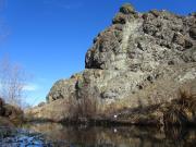
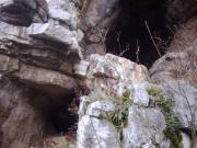
"Kozarskata" cave is located in the Lakatnik karst region, ​​northwestern of Station Lakatnik. The cave is situated close to the place where the river of Preboynitsa (called by some Proboinitsa) flows into the Iskar.The cave entrance is difficult for access. It is situated high over the river and...
Rating: 4 from 0 to 5 - 2 vote(s).
Garvan kamak locality (Village Novi han)
Garvan kamak locality Category: Sanctuary, Rock-formation
Location: Village Novi han »
Garvan kamak (means raven stone) is a rocky peak and a landmark located south of the highway Trakia, not far away from the village of Novi Han. After the name of the peak is named the whole area.The rock is located about 700 meters from the shelter Studenitsa, near to the path leading to the shelter...
Rating: 3 from 0 to 5 - 2 vote(s).
Rock phenomenon Djuglata (Village Tserovo)
Rock phenomenon Djuglata Category: Rock-formation
Location: Village Tserovo »
The Natural phenomenon Dzhuglata (or Djuglata) is located near village of Tserovo, about 8 km north of town of Svoge. This is an impressive rock formation with a height of 18 meters and a strange shape that resembles a human head. It consists of horizontal rock layers, which have survived the ...
Rating: 0 from 0 to 5 - 0 vote(s).
Kuklata rock (Town Slivnitsa)
Kuklata rock Category: Rock-formation
Location: Town Slivnitsa »
The rock of "Kuklata" (means "The doll") is located in the area with same name, about 2 km southwest of the center of Slivnitza. There is a beautiful view to the town and the surrounding villages from here, and the place is a favorite destination for walking and picnicking of local people.About the...
Rating: 0 from 0 to 5 - 0 vote(s).
The Tree with holy waters (Village Bratushkovo)
The Tree with holy waters Category: Fountain, Water spring
Location: Village Bratushkovo »
In the "Manastirishte" locality above the village of Bratushkovo is located a tree whose roots run water. There is a belief these waters are healing, and locals call the place "Holy waters". There is a tourist route from village of Bratushkovo to the site with the springs.Recently the waters are...
Rating: 2 from 0 to 5 - 1 vote(s).
The Dragoman marsh (Town Dragoman)
The Dragoman marsh Category: Reserve
Location: Town Dragoman »
The Dragoman marsh is located in the foot of the karst mountain Chepan, 1.5 km north-east of town of Dragoman in the direction to the village of Golemo Malovo. It occupies an area of about 350000m2.The place was declared a reserve and there are more than 140 plant and 200 animal species (mainly...
Rating: 0 from 0 to 5 - 0 vote(s).
Kostenski waterfall (Village Kostenets (v))
Kostenski waterfall Category: Waterfall
Location: Village Kostenets (v) »
The Kostenski Waterfall is situated on the river Chavcha in the center of the resort area Vili Kostenets (southwest of the village of Kostenets). This is the biggest natural tourist attraction in the municipality Kostenets and there is well marked path to it. The waterfall is very beautiful...
Rating: 0 from 0 to 5 - 0 vote(s).
Skalovitski waterfall (Village Kostenets (v))
Skalovitski waterfall Category: Waterfall
Location: Village Kostenets (v) »
Skalovitski Waterfall is located south of the village of Kostenets near are of Villas Kostenets. The height of the waterfall is 15 meters. There is an eco-path with places for recreation and picnics, and Gurgulitsa hut is situated 2km west of the waterfall....
Rating: 0 from 0 to 5 - 0 vote(s).
Golashkata cave (Village Golak)
Golashkata cave Category: Cave
Location: Village Golak »
"Golashkata cave" is located in the area "Osmansko dere" - 4-5 km. away of village of Golak and about 15 km. away from town of Kostenets. This is not a natural cave but the old mining gallery used hundreds of years ago (according to some theories - even before the Ottoman rule),...
Rating: 0 from 0 to 5 - 0 vote(s).
Rock formations in Petlyuk locality (Village Gurgulyat)
Rock formations in Petlyuk locality Category: Rock-formation
Location: Village Gurgulyat »
Petlyuk locality is situated about 1 km south-east of the village of Gurgulyat and about 2.5 km south-west of the village of Gulubovtsi. Here, almost in line with east-west orientation, are situated three limestone cliffs - Petlyuchki kamik, Ravni kamik and Krivsha.Through the rocks passes river of...
Rating: 0 from 0 to 5 - 0 vote(s).
Vidin Montana Vratsa Pleven Rousse Silistra Dobrich Varna Veliko Turnovo Razgrad Turgovishte Shoumen Bourgas Yambol Sliven Haskovo Stara Zagora Gabrovo Plovdiv Kardjali Smolyan Pazardjik Blagoevgrad Kyustendil Lovech Sofia City Sofia County Pernik